


- Project
Plan canopée et végétalisation de Verviers
- Architect
artau, architectures
Buur (Sweco)
- Programme
Canopy plan and greening strategy for Verviers (Belgium)
- About
The project focuses on designing a comprehensive greening strategy at the scale of the city of Verviers. It is rooted in an integrated urban planning approach, requiring the cross-analysis of a wide range of data and constraints in order to formulate a coherent and structured vision.
The ambition is to develop a clear, adaptable action plan, capable of evolving in line with available resources and shifting priorities over time. This flexibility will allow the municipality to move forward incrementally, taking into account on-the-ground realities and residents’ expectations.
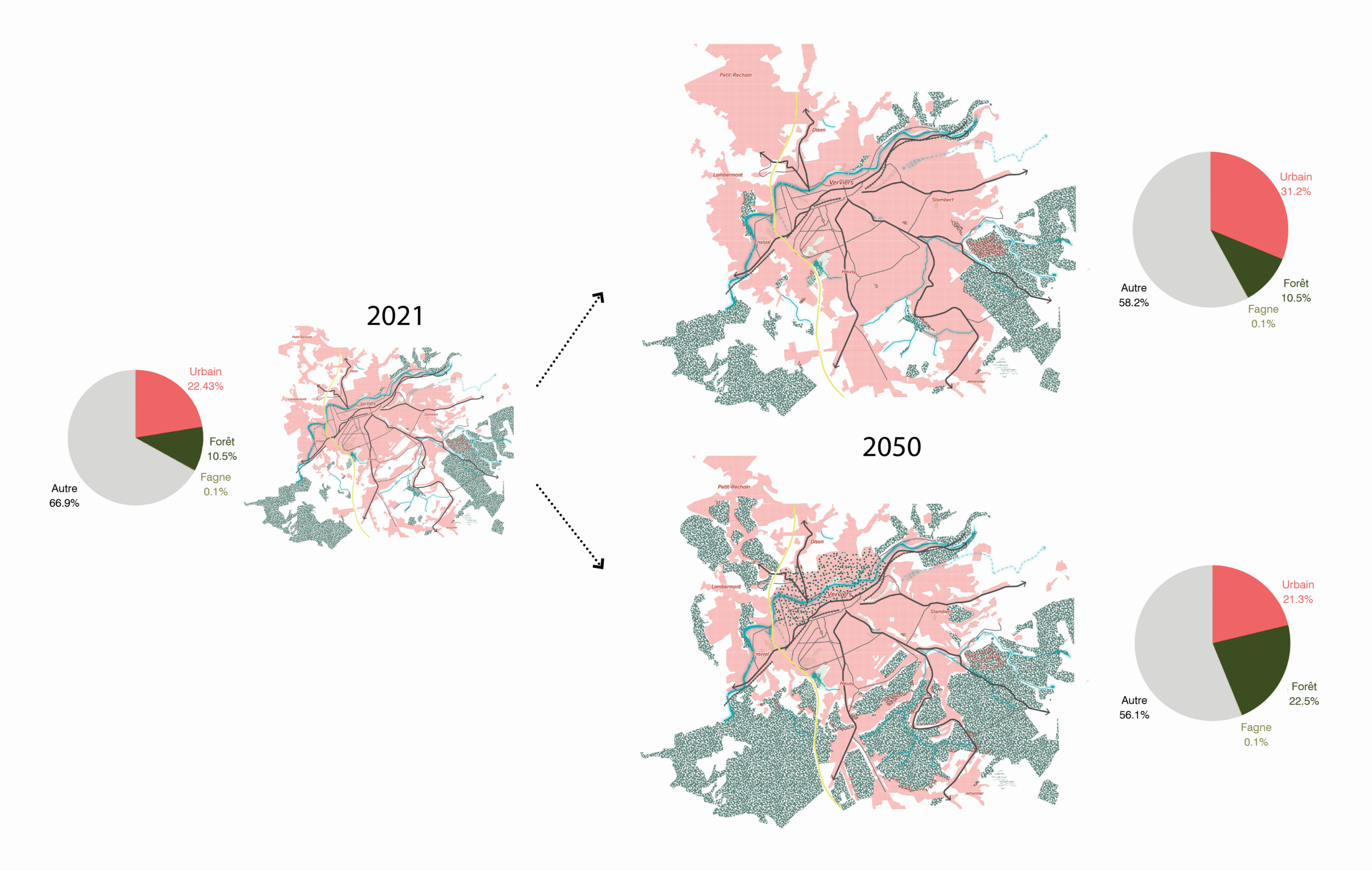
The first phase of the project consists in establishing a precise diagnosis, materialised through the production of a cartographic atlas. This tool provides a comprehensive and legible overview of the current state of urban spaces. To deepen this analysis, a Geographic Information System (GIS) is deployed, incorporating in particular a detailed inventory of trees located on municipal land. The GIS thus becomes an operational tool, facilitating the management and long-term monitoring of the urban tree stock.
The project also предусматриes the development of new indicators, such as a canopy index measuring the extent of vegetative cover, and a mineralisation index intended to quantify sealed and impervious surfaces. These indicators provide clear benchmarks for assessing the impacts of urbanisation and guiding actions towards a more balanced urban environment.
The methodology is based on a rigorous identification of priority areas where interventions will have the greatest impact. Each sector is characterised in detail in order to define specific types of actions, tailored to its needs and potential. The action plan therefore combines transversal measures, applicable across the city as a whole, with targeted projects focused on strategically identified spaces.
Delivering this mission requires a wide range of expertise: in-depth knowledge of landscape and environmental dynamics, urban planning and territorial development skills, the ability to carry out comprehensive urban diagnostics, as well as strong proficiency in GIS tools and cartographic techniques. The identification of plant species and a fine-grained understanding of the local context are also essential assets.
The key challenge lies in bringing together all these areas of expertise to produce a strategic plan that is both ambitious and realistic—one that supports the municipality in moving towards a more sustainable and more liveable urban development. The quality of the project ultimately rests on its ability to transform complex data into concrete actions, serving residents’ quality of life and the preservation of natural heritage.
- Typology
- Paysage, espaces urbains
- Status
- Non construit
- Year of conception
- 2023
- Client
- Ville de Verviers
- Total budget
- 82 590 htva €
4800 Verviers
BelgiumMore information
https://www.artau.beOther projects
Other projects
- ARC complex2017 – 2021Liège


- Rives Ardentes2017 – 2024Liège


- Lennox Residence2006Ottignies


- CHC MontLégia2020Liège


- ULiège Veterinary Clinic2019Liège